

Natural Radionuclide Distribution Mapping in Soils: A Case Study of Al-Najaf and Kufa Regions in Iraq
##plugins.pubIds.doi.readerDisplayName##
https://doi.org/10.70593/978-93-7185-213-5
Keywords:
Natural Radionuclide, Mapping, Soil, Dosimeter, Radiological Risks, CR-39, NaI(Th)Synopsis
The radiological properties of soils represent an important factor for the investigation of the natural background radiation and possible environmental and health hazards. Soils play a role as the main reservoir of naturally-occurring radionuclides, such as uranium (U), thorium (Th), potassium (K) and radium, & their progeny, which are responsible for the external and internal exposure to radiation. The spatial distribution of these radionuclides is not identical, being significantly influenced by geological formations, soil type, and environmental characteristics, so radiological mapping becomes a very important tool regarding environmental characterization and radiation protection.
In this book, a part is dedicated to the principles, methods, and practice of radiologic mapping of soil in limited regions. It gives a round-up of the state-of-knowledge on specific aspects of soil radionuclide transfer following accidents, such as dynamic approaches to model soil transfer both in real and laboratory conditions, data analysis methods used in investigating soil radioactivity, and dynamic model testing. The focus has been on the linking of specific radiological measurements with geospatial devices, primarily Geographic Information Systems (GIS), to allow visualization and interpretation of the spatial distribution of radionuclides and their associated radiological hazards.
The motivation for this research comes from a rising demand of good baseline data on soil radioactivity, particularly in places with limited environmental monitoring infrastructure. Not only do they represent an added value to the scientific knowledge of natural radiation, but a useful tool for environmental management, territorial planning, and public health decision making. Such maps are important for characterization of the high-radiation areas as well as providing guidelines on possible risks to the population and non-human biota.
The intended book users of the present work are researchers, environmental scientists, health physicists, geologists, and post graduate student in the fields of environmental radioactivity and spatial analysis. It will also be useful as a guide for regulatory bodies and radiation monitoring professionals dealing with environmental protection. On the other hand, in terms of practical contribution, it is hoped that by integrating theory with practice-based case studies, this paper will also help promote the development of radiological assessment and the usage of soil mapping as a tool for environmental safety and sustainable development.
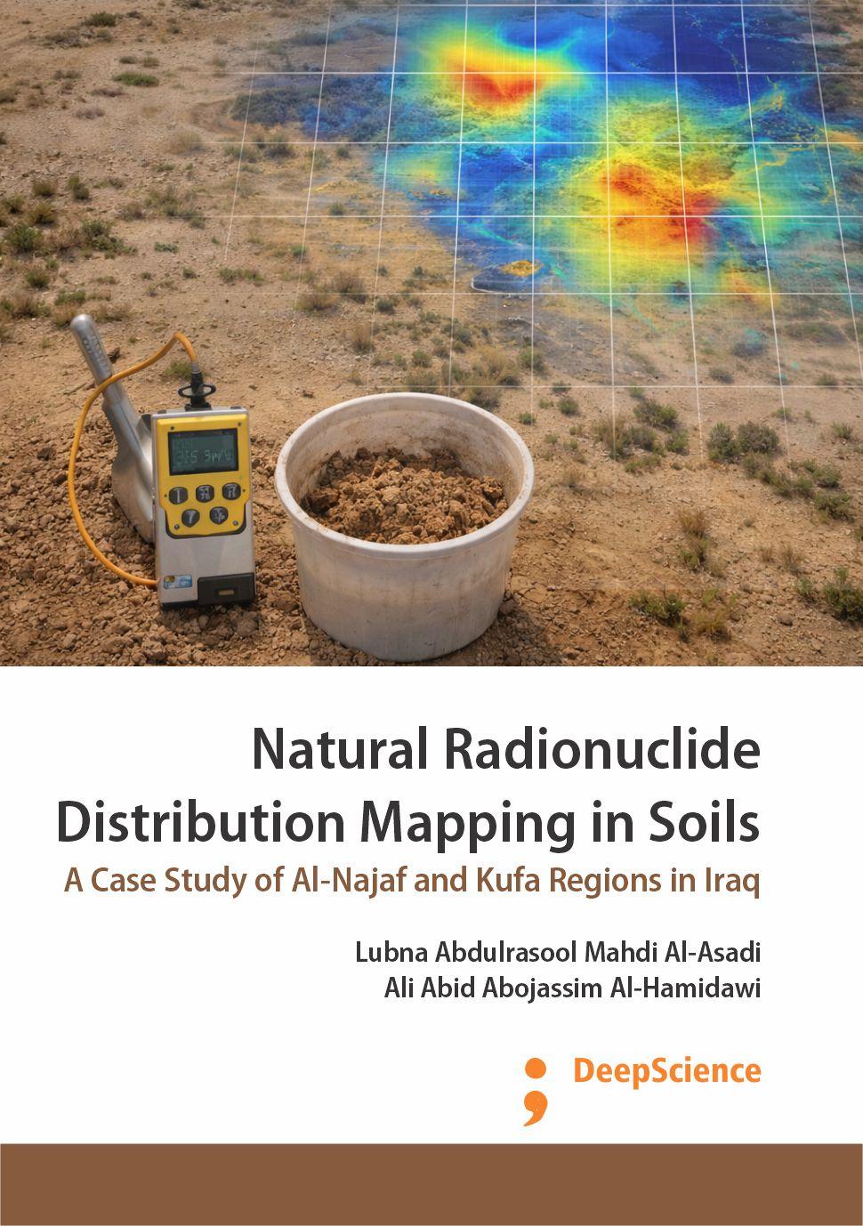
The present study aims at measuring the natural radioactivity of background radiation (Dose rate), gamma emitters (Uranium-238, Uranium-235, Thorium-232, and Potassium-40), and alpha emitters ( Radon-222, Radium-226, and Uranium-238 ) in soil samples collected from two cities, Najaf and Kufa at Al-Najaf governorate. Many techniques have been used, such as Alert INSPECTOR Dosimeter, gamma-ray spectroscopy with NaI(Tl) its dimension 3"× 3", CR-39 of TASTRAK analysis system, and RAD-7 detector, as well as radiological hazard index due to gamma and alpha emitters of samples, are determined. Then, the Geographic Information System (GIS) technique is used to map most main results.
The results using the dosimeter are shown that the average value of Dose rate (D), Annual Average Effective Dose (AAED), and Excess Lifetime Cancer Risk (ELCR) due to the natural background in soil samples for Kufa city are 0.127±0.005 µSv/h, 1.12±0.04 mSv/y and (3.90±0.15) ×10–3, respectively. While, the average values of D, AAED, and ELCR for Najaf city are 0.121±0.004 µSv/h, 1.06±0.03 mSv/y, and 3.73±0.12, respectively.
The results using NaI(Tl) detector are shown that the average value of specific activity in Kufa city for (238U, 235U, 232Th, 40K) are 6.2±0.74 Bq/kg, 278.10±19.43 Bq/kg, 6.41±0.82 Bq/kg, and 278.10±19.43 Bq/kg, respectively. While, the average value of specific activity in Najaf city for (238U, 235U, 232Th, 40K) are 18.01±1.24 Bq/kg, 0.83±0.44 Bq/kg, 13.36±0.91 Bq/kg, and 256.86±12.23 Bq/kg, respectively.
The results using the CR-39 detector are shown that the average value of the radon concentration in the tube's airspace (C), the radon concentration in the sample (CRn), The radium content in the sample (CRa), and uranium concentrations (CU) for Kufa city are 14.1±1 Bq/m3, 895 ± 74 Bq/m3, 0.028±0.008 Bq/kg, and 0.048±0.008 ppm, respectively. While, the average value of the C, CRn, CRa, and CU for Najaf city are 16.10±3.166 Bq/m3, 684.92± 140.5 Bq/m3, 0.029±0.0058 Bq/kg, and 0.036±0.0072 ppm, respectively.
It is found that the highest values of D and AAED due to background radiation in all samples under study are lower than the average worldwide limits of 0.247 μSv/hr and 2.4 mSv/y according to UNSCEAR 2008, respectively. As well as, the specific activity of 238U, 232Th, and 40K are lower than worldwide according to UNSCEAR 2008, except some samples have 40K larger than worldwide. In comparison, the results of alpha emitters in all present study samples are less than the world average levels. At the same time, all radiological parameters due to gamma emitters in most samples in Kufa and Najaf cities are within possible limit according to the radiation protection report UNSCEAR2000, UNSCEAR2008, OECD and ICRP1993. On other hand, the radiological parameters due to alpha emitters in all samples in Kufa and Najaf city, are within possible limit.
Next step, many correlations between detectors are made between three techniques for all areas under study (Kufa and Najaf): first dosimeter and NaI (Tl) detectors, second NaI (Tl), and CR-39 detectors, and third CR-39 with RAD-7 detectors. The study has proved a high correlation factor for all the present study samples. This is evidence that the soil samples under study are original and affected by Goegical area and filtration. Thus the correct sequence of the uranium-238 basket can be achieved. Also, a good association between the Uranium-238 and Radon -222 would be considered statistically significant, but there is a weak association for all sites in the present study between radon-222 with thorium-232 and potassium-40; no one found the relation between radon-222 with thorium-232 series inside and potassium-40 from another side. Also, a good relationship between passive and active techniques.
At last, the study results are safe compared with the permissible values globally, except for some area that needs future studies.
References
A.A.Abojassim, “Alpha particles concentrations from some soil samples of al-najaf (Iraq),” Polish J. Soil Sci., vol. L/2, pp. 249–263, 2017.
H. N. Azeez , M. H. Kheder, M. Y. Slewa and Y. Sleeman. “Radon Concentration Measurement in Ainkawa Region Using Solid State Nuclear Track Detector,” Iraqi J. Sci., vol. 59, no. 1B, pp. 482–488, 2018.
K. M. Thabayneh, “Determination of radon exhalation rates in soil samples using sealed can technique and CR-39 detectors,” J Environ Health Sci Engineer ,vol. 16, no.2, pp. 121–128, 2018.
A. Elzain, H. Idriss, Y. S. Mohammed, K. S. Mohamed, M. A. Ali, M. S. Elkhalig, I. Salih, A. K. Sam, M. H. Eisa, S. S. Mahmoud and M. K. Massoud, “Assessment of radioactivity from selected soil samples from Halfa Aljadida area, Sudan,” Radiochim. Acta, vol. 107, no. 6, pp. 489–502, 2019.
M. H. Kheder, “Measurement of Radon Concentration Using SSNTD in Bartella Region,” Al-Mustansiriyah Journal of Science, vol. 29, no. 4. p. 110, 2019.
Downloads
Published
13 February 2026
Copyright (c) 2026 Lubna Abdulrasool Mahdi Al-Asadi, Ali Abid Abojassim Al-Hamidawi
Details about the available publication format: E-Book
E-Book
ISBN-13 (15)
978-93-7185-213-5
Details about the available publication format: Book (Paperback)
Book (Paperback)
ISBN-13 (15)
978-93-7185-020-9
How to Cite
Al-Asadi, L. A. M. ., & Al-Hamidawi, A. A. A. . (2026). Natural Radionuclide Distribution Mapping in Soils: A Case Study of Al-Najaf and Kufa Regions in Iraq. Deep Science Publishing. https://doi.org/10.70593/978-93-7185-213-5
Download Citation


 WhatsApp +91 7977171947